China, Nepal to unify Qomolangma's height

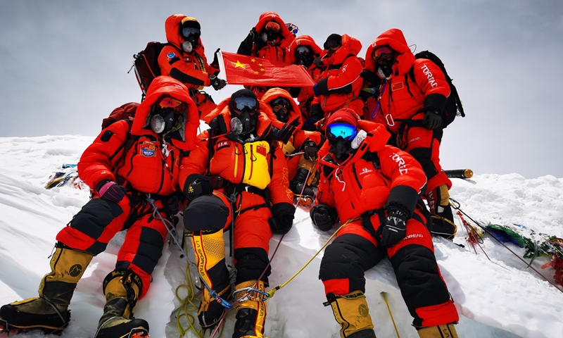
Chinese surveyors pose for a group photo atop Mount Qomolangma on Wednesday. The surveying team reached the summit on Wednesday with the trek being a crucial step in the country's mission to re-measure the height of the world's tallest peak. Photo: Xinhua
Chinese netizens are on edge over the new height of Mount Qomolangma, more commonly known as Mount Everest, as China and Nepal, the two countries where the mountain crosses, are expected to jointly announce a unified measurement of the world's highest peak, which could be as soon as Tuesday, media reported.
Susheel Dangol, a Nepali official in charge of the measurement project, said that China and Nepal will announce the height on Tuesday, the Wall Street Journal reported Sunday.
Although the Chinese Ministry of Natural Resources declined to reveal details of the joint announcement as of Monday afternoon, sources close to the matter told the Global Times that there would be a statement on Tuesday in Beijing.
Nepal authorities did not respond to a Global Times inquiry as of press time.
On China's Twitter-like Sina Weibo, several online polls have been put up to discuss the newest height of the mountain, which straddles Southwest China's Tibet Autonomous Region and Nepal.
Thousands of netizens left comments for the Ministry of Natural Resources, a government body in charge of the measurement work, and urged a final settlement - some said Qomolangma remains at 8,848 meters, while others saw a minor adjustment.
According to a joint statement signed by the two countries in October 2019, the two sides will promote cooperation in different fields, including addressing climate change and protecting the environment, and jointly announce the height of Mount Qomolangma and conduct scientific researches, the Xinhua News Agency reported.
"To reach a consensus on the issue reflects the two countries' mutual respect and willingness to extend cooperation by promoting information sharing," Ruan Zongze, executive vice president of the China Institute of International Studies, told the Global Times on Monday.
Mount Qomolangma could be seen as a symbol of friendship between the two countries, Ruan said. Rather than surveying the height separately, China and Nepal agreed on a unified result, similar to the mountain's area division, he noted.
Observers said the result could also give great value to the study of the Earth's geodynamic plate motion. Data such as peak snow depth, weather and wind speed will provide first-hand information for research on glacier monitoring and ecological environment protection.
China's research team carried out the seventh round of survey this May, achieving multiple technological breakthroughs, including the use of BeiDou Navigation Satellite System, and real-scene 3D technologies to obtain a reliable, accurate result and the status of natural resources on the mountain.
A mountaineer named Maliyamu from Xinjiang who climbed Qomolangma with the Nepal survey team in 2019 said that she and her Nepali friends will always look at the mountain in awe, no matter how tall it is. "For me, to challenge the formidable height and wave the Chinese national flag on top of the mountain are the true meanings," she told the Global Times.
The previous calculation by Chinese researchers stands at 8,844 meters from a 2005 survey, while Nepal said it was a little taller, at 8,847 meters. The two countries are about to close the 3-meter gap in the upcoming announcement.
Earthquakes that take place in the nearby region have affected the height of the mountain. And to what extent the 2015 Nepalese earthquake had on the mountain's height, with the epicenter being 200 kilometers away, has not been verified in the international community, which has called for a re-measurement, said Dang Yamin, the project leader of this year's Chinese survey.
Newspaper headline: China, Nepal to jointly announce new height of Mt. Qomolangma