Home >> Metro Shanghai
High life and low living
By Duan Wuning Source:Global Times Published: 2013-5-27 18:43:01
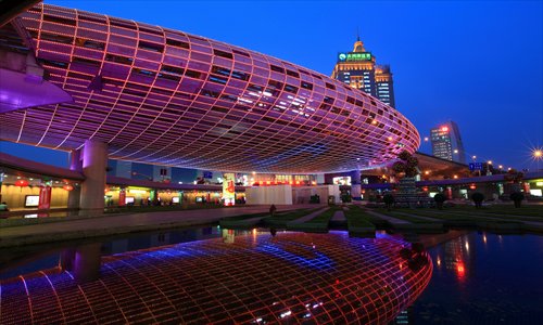
Wujiaochang in Yangpu district was once regarded as part of Lower Shanghai but has now flourished into one of the city's most prosperous commercial areas. Photo: CFP
There's no real defined area now for Upper Shanghai. But the term, which is commonly used in the city, is not an invention of real estate agents or property developers. Throughout its history there has almost always been an upper and a lower Shanghai.Upper Shanghai could at times refer to a geographical area often incorporating the high-end residential areas in the west of the city. Lower Shanghai wrapped up the area of cheaper housing - the rental gaps between upper and lower homes could be as much as 10 times in the old days.
There were historical reasons for this. Before the liberation of the city in May 1949, the city had been divided into the concessions. The most famous was the former French concession which sprawled around today's Huaihai Road. The former International concession was found around Nanjing Road and was home to compradors, foreigners and celebrities. Rich people lived lives of quiet luxury along roads like Yuyuan Road, Hunan Road and Yuqing Road.
Factory based
In northeast Yangpu, Zhabei, Putuo and Baoshan districts, there were different lifestyles. The people here were based around factories and for some in the city Lower Shanghai was to be found to the north of the Suzhou Creek - the opposite banks of the creek were home for those who lived in the upper part of the city.
Lower Shanghai was poor, overcrowded, bustling, and its narrow streets swarmed with workers. The streets - the jialong - were named after families who had settled there. Like Meijialong in the current Dongjiadu area in Huangpu district. Sometimes the streets were named after the items that were sold or made there, like Caoxiewan (straw sandal creek) Road or Luxi (reed mat) Street.
It wasn't just the homes that looked different. There were different lifestyles and custom. While affluent residents in Upper Shanghai drank coffee and danced the tango, in Lower Shanghai the people lived in shacks, washed clothes for a living and emptied their chamber pots on the street. But there were never great physical distances between the two. Just a few meters, a laneway or a street separated them.
Shanghai's urbanization started after the city was opened up for trade in 1843 after the Qing government lost the First Opium War (1840-42) with Britain. The opening-up led to the establishment of the concessions.
The first concession
Shanghai's first concession (and the first in China) was the former British concession and it was established in November 1845 after the Qing government and the Britain consul of the day announced "The Shanghai Land Regulations," which paved the way for other concessions. The US and France followed, setting up their concessions in 1848 and 1849. The former American concession was where Hongkou district is found today.
The former British and French concessions were more prominent, being found closer to the old town of Shanghai which was located where the Yuyuan Garden is now. Upper and lower areas kept changing. Shanghai's urban planning moved up a level in 1959, when the city expanded from its previous 600-square-kilometer area to an area covering 6,000 square kilometers. The old upper and lower parts of town were no longer so clear.
Before 1959, Shanghai didn't have any rural areas of its own. Shanghai was an industrialized city focused on trading. The city itself could never supply food, rice and daily necessities for its 4 million residents.
With the expansion this problem was solved by including vast swathes of countryside and farmland into the city area. The State Council approved the inclusion of Songjiang, Jiading, Fengxian, Nanhui (which merged into Pudong New Area in 2009), and Baoshan districts, Chuansha town (also now part of Pudong), as well as Chongming county.
Prior to the expansion, all the land beyond the Inner Ring Road in the west belonged to Jiangsu Province. Chongming county used to belong to Nantong, Jiangsu Province. Upper Shanghai has changed as the city developed and expanded.
At the same time, Shanghai's structure had been changing. The city had shifted its focus to commerce while manufacturing industries were gradually moved to the suburbs. With this transformation, the city landscape changed. After the factories moved out, downtown changed and the new look encompassed and extended Upper Shanghai.
Every new round of urban planning sees the old areas of Lower Shanghai vanishing and becoming new growth areas. And as these areas flourish and shake off their working-class backgrounds, the areas of Upper Shanghai are being renovated. Today's Upper Shanghai is more about the high-quality buildings and residences than it used to be.
Wealth and poverty
There's probably no another city in China that has had such obvious upper and lower areas as Shanghai. At first sight it seems to be about locations but there's a deep-set understanding in the city that the division is more about wealth and poverty.
In Shanghai social status counts a good deal. Even the old ladies who cleaned toilets in Upper Shanghai apparently felt superior to their counterparts in Lower Shanghai.
There was also a lot of middle ground or undefined areas. Many of the city's literati lived around Sichuan Road North in Hongkou district, including the most famous of them all, the writer Lu Xun. For most writers of the era, Upper Shanghai was for the rich and Lower Shanghai was for the poor.
"If you enter a longtang (lane), you will find urinals, snack stalls, swarms of flies, children fighting, angry disturbances and bitter cursing. What a disorderly small world!" Lu Xun wrote in his article, Children in Shanghai, depicting a working-class longtang.
Although they couldn't afford an apartment in Upper Shanghai, the writers believed their locations were just as decent.
The shanty towns
The thought of Lower Shanghai also evokes pictures of shanty towns. There's a proverb: "If you didn't develop in your previous life, you will have to live in a shanty town in this life." Before liberation this was a popular saying among the workers in northeast Yangpu district. Their homes were often thrown together with bamboo, sticks, straw and clay. Garbage and filth was spread everywhere. It stank to high heaven and got worse during the Plum Rain season.
Their homes had no electricity or water supplies. Even today some of the residents in this area have to have their chamber pots collected early in the morning.
It was the migrant farmers and workers coming to Shanghai who had to live here. They didn't have the money to rent real houses so they created shanty towns on unused land, by the sides of roads and rivers and around factories. The slums started more than a century ago on the banks of the Huangpu River and Suzhou Creek, and made their way inland, finally sprawling over much of the city center.
The continuous warfare that involved the city exacerbated the expanding slums. In 1860 when the Taiping Army surrounded Shanghai, merchants and landlords swarmed into the concessions. Overnight the concessions were overpopulated. Some businessmen saw this as an opportunity and built makeshift housing, renting it out for exorbitant rates.
During the Japanese invasion in the 1930s, Shanghai was bombed and homes in Zhabei, Hongkou and Nanshi (Huangpu today) districts were destroyed. Refugees fleeing these attacks assembled on the north bank of the Suzhou Creek adding more huts, hovels and makeshift homes.
Burned down
The slums had always been headache for administrators. In 1925, the administrators of the former International concession set fire to around 1,000 slum homes on the current Pingliang Road (Yangpu district) after other attempts at clearing them up had failed. In 1936, the slums in Zhabei were also burned to the ground when the residents refused to move out.
Though some slums had been razed like this when Shanghai celebrated its liberation in 1949, there were still some 1.15 million people living in 197,500 dilapidated houses covering 1,100 hectares.
The city government started demolishing the slums in these areas and built new residential compounds for the residents. It was a long process. By 1990 the city still had 365 hectares of slums to clear.
Zhaojiabang Road, which links Huangpu and Xuhui districts, was one of the redevelopment projects. Originally it was a 10-kilometer river that connected the Huangpu River with Songjiang. After the French built a cathedral in Xujiahui in 1910 and built roads around it, the river was disconnected from its upper reaches.
Refugees from neighboring provinces came down the river on their boats and lived there on their boats. It became a major slum after the outbreak of the War of Resistance against Japanese Aggression (1937-45). After the cathedral was vandalized during the Cultural Revolution (1966-76), it reopened in 1978. It has been largely restored and is now the center of a lush boulevard.
With the city continuing to develop, the upper and lower city areas will also develop. Shanghainese used to say about Pudong, before it was redeveloped in the early 1990s, that people in Shanghai would rather have a bed in Puxi than a house in Pudong. Now it has become an internationally popular place to live. One of the new parts of Upper Shanghai perhaps.
Posted in: Metro Shanghai, Meeting up with old Shanghai